Field Note
Best Fishing Apps for Trip Planning, Tides, Maps, and Logs
Compare fishing apps for free and paid trip planning: tides, maps, weather, logs, solunar windows, and Northeast coastal use.
Updated May 20, 2026
Planning note
Some articles reference earlier seasons, model years, or product availability. Confirm current details before buying gear or planning around a specific regulation, launch, or access point.
Quick take
The best fishing app is usually a small stack, not one magic download: use official tide and weather data for timing, a mapping app for access and structure, a logbook for patterns, and a paid fishing app only when its charts, contours, forecasts, or community data solve a real problem for the water you fish.
Last checked May 20, 2026. App features, subscriptions, free trials, and regional coverage change often, so verify current details in the app store or official product page before paying.
Free vs paid fishing apps
| App or tool | Free use | Paid use | Best for Northeast anglers | Watch-out |
|---|---|---|---|---|
| NOAA Tides and Currents | Free web data | None from NOAA | Tide height, current predictions, water levels, and official station data | It is official data, not a fishing forecast |
| National Weather Service | Free web data | None from NWS | Marine forecasts, wind, fronts, lightning risk, and trip safety | You still need local interpretation |
| Fishing Points | Essential free features | Premium adds advanced tools | Tides, solunar windows, weather, maps, waypoints, and catch logs | Premium value depends on how much you use one app |
| Fishbrain | Free app and community access | Pro unlocks more mapping/forecast features | Finding species history, logging catches, and scouting unfamiliar water | Community catch points can be incomplete or intentionally vague |
| Navionics Boating | Limited trial/free app access | Annual subscription for charts and advanced features | Nautical charts, contours, route planning, waypoints, and boat use | It is a boating/navigation tool first, not a bite guarantee |
| Google Maps or Google Earth | Free | None for basic use | Parking, access, satellite scouting, beach shape, marsh edges, and route planning | It will not replace current tide, weather, or regulation checks |
The best fishing app stack
For most surf, shore, and small-boat trips, start with this order:
- Weather and marine forecast: Check wind, fronts, lightning, fog, visibility, sea state, and temperature before thinking about lures.
- Tides and currents: Use official tide/current data to understand when water will move, drain, flood, or stack against structure.
- Map and access scouting: Look for parking, walk distance, points, bars, cuts, bridges, ramps, marsh drains, and nearby bailout options.
- Logbook: Save date, tide stage, wind, moon, water clarity, lure, depth, and what actually happened.
- Paid fishing layer: Add a premium app only if it gives you contours, forecasts, waypoints, or community data you will actually use.
That stack works better than letting one app tell you a “best time” without context. A solunar window can be useful, but Northeast coastal fishing still runs through wind, bait, water movement, access, and safety.
Best free fishing apps and tools
NOAA Tides and Currents
NOAA is the baseline for tide and current data. Use it when the question is factual: high tide, low tide, current prediction, water level, or station observation. For surf fishing, it helps you plan when bars, troughs, and inlet edges may start moving. For boat fishing, it helps you understand current windows before choosing a drift, inlet run, or ramp timing.
National Weather Service
The National Weather Service is the official weather layer to check before you trust an app’s summary. For anglers, the useful pieces are marine forecasts, wind direction, gusts, small craft advisories, thunderstorms, fog, and fronts. Fishing apps can repackage weather nicely, but the official forecast is still the anchor.
Google Maps and Google Earth
Google’s map tools are not fishing apps, but they are still part of the free fishing toolkit. Use satellite view to inspect parking, sand, rocks, points, marsh edges, ramps, jetties, bridge access, and walking distance. Then pair that scouting with current tide and weather data.
Paid fishing apps worth comparing
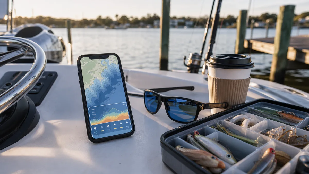
Fishing Points
Fishing Points is a useful all-in-one trip planner because it combines maps, tides, forecasts, solunar timing, waypoints, and catch logging. Its official help describes coverage for coastal fishing data such as tides, marine info, nautical maps, solunar information, weather, and logs. It is a good fit if you want one clean app for planning and notes.
Fishbrain
Fishbrain is strongest as a community, mapping, forecast, and logbook app. Fishbrain says its tools include catch locations, depth maps, fishing forecasts, and a logbook built from a large angler network. It can be useful when you are learning a new pond, lake, river, or region, but treat any shared spot as a clue, not a promise.
Navionics Boating
Navionics is the serious map layer for boaters and anglers who want nautical charts, bathymetry, route planning, waypoints, offline charts, and chartplotter syncing. Garmin describes the app around detailed nautical charts and HD bathymetry, with premium overlays and chartplotter features. It makes the most sense for boat, kayak, and route-planning use.
Which app should a Northeast coastal angler start with?
If you fish from the beach, start free: NOAA tides, NWS marine forecast, Google satellite view, and a simple log. Add Fishing Points if you want one app to hold waypoints, tides, forecasts, and catches.
If you fish from a small boat, compare Navionics and your fish finder/chartplotter ecosystem before paying for another app. You may care more about chart quality, offline coverage, route planning, and syncing than a generic fishing forecast.
If you are learning new freshwater or mixed inshore water, Fishbrain can be useful for species clues, catch history, and logging. Keep your own best spots private and use community data with skepticism.
How to use fishing apps without getting fooled
- Do not treat “best time to fish” as a command. Confirm tide, wind, bait, water clarity, access, and safety.
- Log blank trips. They are the data that tells you what not to repeat.
- Separate public catch reports from your private pattern notes.
- Save official regulation links outside the app if you fish across state lines.
- Confirm paid features before subscribing. Contours, offline maps, logs, and forecasts vary by region and platform.